


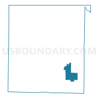
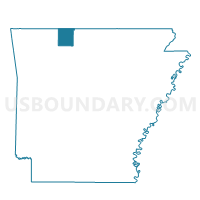
Olevy Voting District, Boone County, Arkansas
About
Outline

Summary
| Unique Area Identifier | 526014 |
| Name | Olevy Voting District |
| County | Boone County |
| State | Arkansas |
| Area (square miles) | 11.84 |
| Land Area (square miles) | 11.82 |
| Water Area (square miles) | 0.02 |
| % of Land Area | 99.87 |
| % of Water Area | 0.13 |
| Latitude of the Internal Point | 36.19873750 |
| Longtitude of the Internal Point | -92.95998570 |
Maps

Graphs
Select a template below for downloading or customizing gragh for Olevy Voting District, Boone County, Arkansas


Neighbors
Neighoring Voting District (by Name) Neighboring Voting District on the Map
- Bellefonte Voting District, Boone County, AR
- Blythe Voting District, Boone County, AR
- Elixer Voting District, Boone County, AR
- Jefferson Voting District, Boone County, AR
- Prairie Voting District, Boone County, AR
- Zinc Voting District, Boone County, AR
Top 10 Neighboring County Subdivision (by Population) Neighboring County Subdivision on the Map
- Elixir township, Boone County, AR (2,802)
- Bellefonte township, Boone County, AR (2,380)
- Jefferson township, Boone County, AR (1,202)
- Zinc township, Boone County, AR (585)
- Prairie township, Boone County, AR (444)
- Olvey township, Boone County, AR (440)
- Blythe township, Boone County, AR (245)
Top 10 Neighboring Unified School District (by Population) Neighboring Unified School District on the Map
- Harrison School District, AR (21,103)
- Bergman School District, AR (4,967)
- Valley Springs School District, AR (4,243)